-
Parrot ANAFI USA GOV Edition - Call to request information - Quote
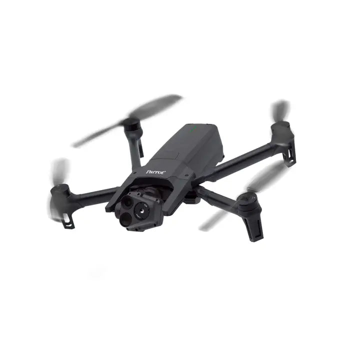
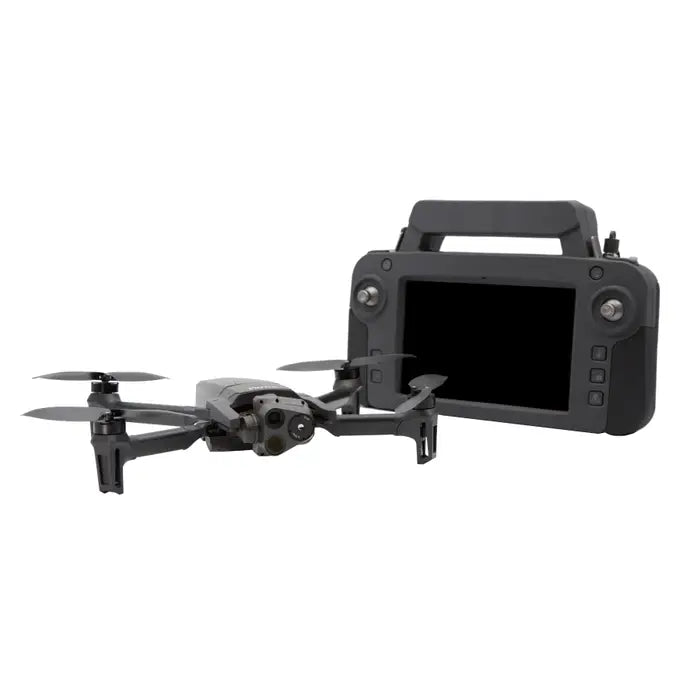
French firm Parrot and the United States Army worked together to develop this highly capable and adaptable drone: the Parrot ANAFI USA GOV Edition. This drone was developed in Massachusetts, United States of America. This UAV has a 32x digital zoom system, two 21-megapixel cameras, and a FLIR Boson® 320 longwave infrared (LWIR) thermal camera with a 320 x 256 resolution, and is designed for usage by first responders, firefighters, SAR teams, and security teams.
GOV Edition Features
ANAFI USA GOV and Skycontroller USA GOV are completely compliant with the TAA and NDAA.
Fly in perfect operational privacy with a data-empty drone.
Worldwide Wi-Fi bandwidth based on U.S. standards
To get the most airtime and range, turn off the auto-RTH feature.
Import KML and TMS map tiles to keep your situational awareness up to date.
Drone lights can be controlled for stealth missions.
32X zoom and a powerful thermal camera
The ANAFI USA's thermal imaging capabilities aid in the location of victims during search and rescue missions, as well as provide crucial information during firefighting operations. The drone's small size and low weight make it simple to transport and deploy in even the most distant regions, and its advanced features make it a valuable tool.
You need a drone that can be launched fast and easily when seconds count. The Parrot Anafi USA can be up and running in about 55 seconds, making it ideal for first responders and other professionals that need to deploy a drone rapidly. The Anafi USA is ideal for missions where speed is critical, thanks to its secure radio link and simple controls.
The Parrot Anafi USA is an excellent indoor and outdoor drone. It is simple to use and ideal for any situation because it can take off and land in your hand. You can fly the Anafi USA indoors with confidence thanks to GPS, and its long battery life allows you to stay in the air for longer.
Flight ready in 55s. Zero no-fly zone limitation
This is the ideal UAV for first responders who need to be able to fly at any time. The Anafi USA allows first responders the freedom to fly responsibly wherever their operations may take them because it has no built-in constraints for no-fly zones. The Anafi USA is also the quietest drone in its class with a sound level of just 79 dB at 50cm off the ground. The Anafi USA also comes with a standard USB-C charger for increased convenience. Look no farther than the Parrot Anafi USA if you're looking for a drone that can help you save lives and make a difference.
For optimal portability, the ANAFI USA folds down to roughly 500 g (1.1 lbs). Despite its small size and compact construction, ANAFI USA's 32-minute flight time is the best in its class for a drone of its size.
The ANAFI gimbal and zoom's sophisticated optics were created to aid firefighters on the scene in assessing a huge fire. The 32x zoom capabilities provide operators with up-close views from 3 miles distant, as well as wide-angle coverage all around them. You can observe every detail inside your assigned area, and even further if necessary, thanks to the strong camera system!
The advanced thermal imaging camera can identify hot spots up to 2 kilometers away while giving operators a good image of individuals and other crucial details.
By combining gimbal stabilization with full 3-axis digital stabilization via image processing, Parrot was able to achieve outstanding image stabilization on 32x zoom photos using a light drone (500 g/1.1 lbs).
Made in the United States of America. Blue sUAS approved. Compliant with the NDAA and TAA.
If the drone or SD card is lost, the ANAFI USA's Secure Digital (SD) card encryption technology ensures that all photographs and movies are completely protected.
ANAFI USA also offers a secure WPA2 Wi-Fi connection that may be used to verify and encrypt the link between the remote controller and the drone. Signed firmware prevents tampering with the drone's software. Wi-Fi, WPA2, RTP/RTSP, H.264, and GUTMA are also used by Parrot to provide compatibility and security of all recorded data.
The FreeFlight 6 software allows users to share data. By default, no data is shared without the user's agreement. When you opt in, flight data and logs are stored on secure servers in Europe and on the drone. The features of the drone are GDPR-compliant (GDPR).
The largest ecosystem for drones
Because it is compatible with Pix4Dreact, the industry's leading mapping program, ANAFI USA allows first responders to convert pictures into accurate 2D maps on a laptop in seconds. By providing an open-source software development kit (SDK) and employing industry-standard protocols, ANAFI USA supports a growing ecosystem of professional apps and services.
Rugged and Ready. IP53 certified
ANAFI USA received an IP53 rating. For missions in tough environments, it's weatherproof and dust-resistant. In 15 m/s winds, ANAFI USA's stabilization assures high-quality film.
The enhanced flight features of ANAFI USA fulfill the expectations of enterprise drone users. With Parrot's FreeFlight 6 software, pilots have a variety of simple flight options. ANAFI USA's flight paths can be defined by coordinates or flown independently. Team missions are made simple by creating a flight plan with pre-set automatic flights and target tracking.
The drone has an editable "Return to Home" (RTH) capability that lets users program a specific "home" position for quick mission completion. When the drone disconnects or runs out of charge, the RTH feature activates automatically, making it simple to keep your drone secure. The innovative tracking system developed by ANAFI USA assists emergency personnel in promptly locating missing people or hazardous goods.
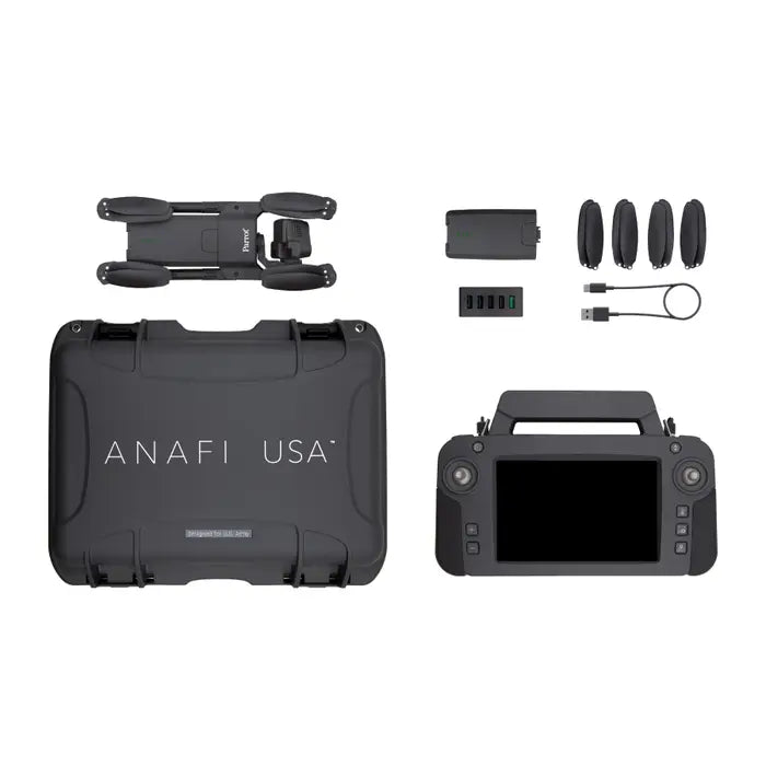
What's in the box:
1x ANAFI USA drone
3x smart batteries (3x32 minutes)
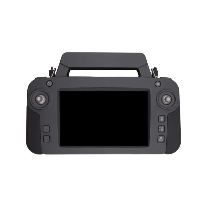
1x Skycontroller USA with its 8-inch display
1x multi-port fast USB charger
1x Skycontroller USA charger
1x additional set of propeller blades
3x USB-A/USB-C cables
1x USB-C/USB-C cable
1x hard case
1x sunvisor
1x neck strap -
Software-unlock maximum ascent speed: 6 m/s
Disable the LED Lights
Customize or disable the auto-RTH function to maximize airtime and range
Import KML and TMS map tiles for up to date
and optimal situational awareness
Share precise co-ordinates
Take off / land from the hand
Take off from a moving vehicle or vessel
External antenna connection for in-vehicle user environments
Cursor on Target feature: indicates the coordinates and location of a point target on the screen
RJ45 / LAN port on Skycontroller USA -
Drone
Mass: 496 g / 1 lb.Maximum take-off mass (MTOM): 644 g / 1.42 lb.
Maximum transmission range: 5 km (3.1 mi)
Maximum flight time: 32 minutes
Maximum horizontal speed: 15 m/s
Maximum vertical speed: 4 m/s
Maximum wind resistance: 15 m/s
Maximum propeller speed: 11,000 rpm
Sound power level at 1 m (3 ft): 84 dB
Service ceiling: 5,000 m above MSL (Mean Sea Level)
Optional altitude fencing and geocaging
Operating temperature: -32 °F (-35 °C) to +120 °F (+49 °C)
IP53 certified (dust and rain resistant)
No take-off temperature limitation
No NFZ (no-fly zone) limitation
Takes off from / lands in the hand of the operator
Security
Manage your data privately between drone and device OR share anonymous data on secured European serversMicroSD card encryption:
LUKS2 volume with AES-XTS protocol
512 bits key
WPA2 AES CCMP encrypted network connectionsDigitally signed authenticated firmware
Dimensions
Size folded: 252x104x82 mmSize unfolded: 282x373x84 mm
Sensors
Satellite navigation: GPS, GLONASS & GALILEOBarometer and magnetometer
Vertical camera and ultra-sonar
2 x 6-axis IMU
2 x 3-axis accelerometers
2 x 3-axis gyroscopes
EO image chain
2 sensors: 1/2.4"Digital zoom: 32x
Electronic shutter speed: 1 s to 1/10,000 s
ISO range: 100-3200
Video resolution: 4K/FHD/HD
Video format: MP4 (H264)
Photo resolutions:
Wide: 21 MP (84° FOV)
Rectilinear: up to 16 MP (up to 75.5° FOV)
Photo formats: JPEG, DNG (Digital NeGative RAW)IR image chain
Sensor: FLIR BOSON320x256 resolution
Temperature range: -40 °C to 150 °C
Thermal sensitivity: <60 mK
Measured IR wavelength range: 7.5 to 13 micrometers
Photo format: JPEG
Video format: MP4 (H.264)
Video recording resolution: 1280x720
Framerate: 9 fps (15 fps for ANAFI USA MIL)
Image stabilization
3-camera IR/EO stabilized gimbalHybrid stabilization: 3-axis:
Mechanical: 2-axis (roll / pitch)
Electronic (EIS): 3-axis (pitch / roll / yaw)
Controllable gimbal tilt range: -90° to +90°Fast-charging smart battery
Type: High density LiPo (3 x 4.4 V cells)Capacity: 3,400 mAh
Battery life: 32 minutes
Charging port: USB-C
Charges in 2h with a USB-PD (Power Delivery) charger
Mass: 195 g / 0.43 lb.
Voltage: 11.55 V
Maximum charging power: 30 W
Parrot Skycontroller USA
Size: 313x208x72 mmMass: 1.25 kg / 2.76 lbs.
TAA & NDAA compliant
Transmission system: Wi-Fi 802.11a/b/g/n (Wi-Fi beacon)
Operating frequencies: 2.4 - 5.8 GHz
Maximum transmission distance: 5 km / 3.1 mi
Resolution of live video feed: HD 720p
2h charging time for 4h30 battery life
Based on the 8" Samsung Galaxy Tab A (2019)
IP53: dust and rain resistant
-
Limited